
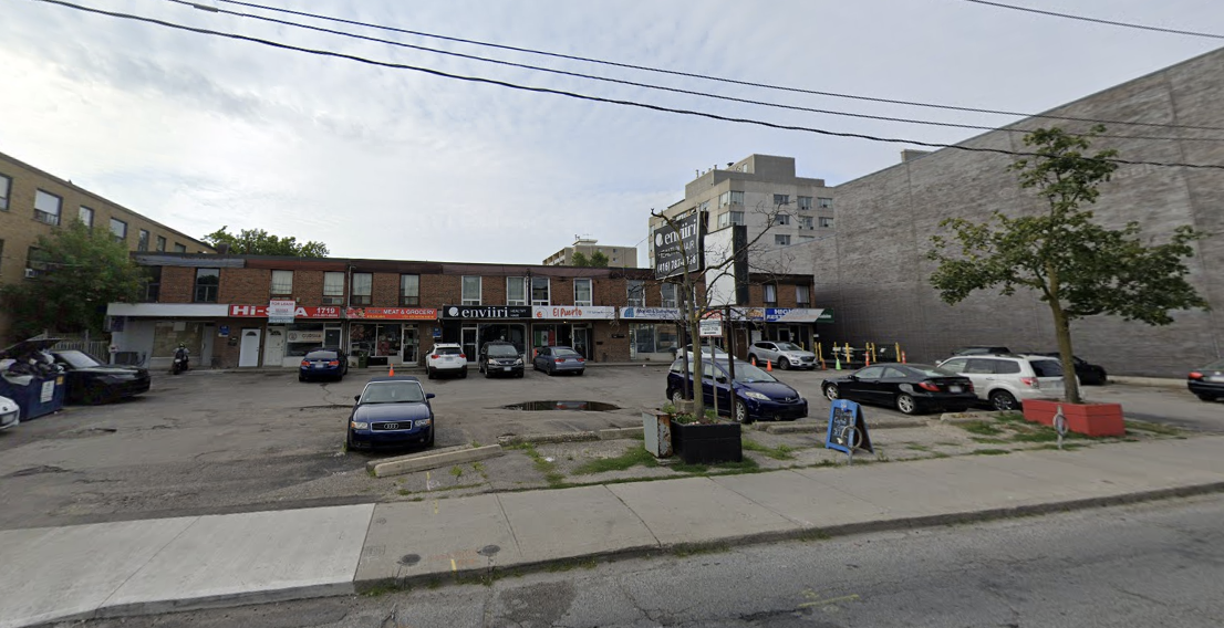
The development proposal at 1711–1741 Eglinton Avenue West sits on the south side of Eglinton, between Northcliffe Boulevard and Glenholme Avenue, on the northern border of Oakwood Village. Today, the site is occupied by a low-rise commercial strip plaza with ground-floor retail and a small number of residential rental units above. In planning terms, however, this property has become strategically important.
It is immediately east of the approved redevelopment at 1675–1685 Eglinton Avenue West, west of the Maria A. Shchuka Library, and within walking distance of the future Fairbank Eglinton Crosstown LRT station near Dufferin Street. City Planning has been reviewing these sites together, not as isolated proposals, but as part of a coordinated stretch of redevelopment along Eglinton West where land use, height transitions, access, and public realm improvements are intended to work as a system rather than parcel by parcel.
What’s Being Proposed at 1711–1741 Eglinton Avenue West
The approved application permits a 39-storey mixed-use building rising to 129.5 metres (excluding the mechanical penthouse). The building would contain a total gross floor area of approximately 26,800 square metres, translating to a density of about 12.8 times the area of the site.
From a planning perspective, this represents a significant increase over what is currently permitted under zoning, which capped the site at roughly eight storeys. That increase in scale is the reason both an Official Plan Amendment and a Zoning By-law Amendment were required.

Residential Breakdown
The proposal includes 427 residential units, with a unit mix designed to meet the City’s family-housing and complete-community objectives. The breakdown consists of studios, one-bedroom, two-bedroom, and three-bedroom units, with approximately 28 per cent of the suites having two or more bedrooms.
Included in the total are eight three-bedroom rental replacement units. These units are intended to replace existing rental housing currently on the site and are addressed through a separate Rental Housing Demolition and Replacement application, which runs parallel to—but distinct from—the zoning and Official Plan approvals.

The Ground Floor — Retail, Community Space, and the Public Realm
Retail and Community Space
At grade, the building is designed to remain active and publicly oriented. The proposal includes a modest amount of commercial-retail space along Eglinton Avenue West, maintaining a retail presence on the street rather than turning inward or becoming residential-only.
In addition, the applicant has proposed an approximately 363-square-metre indoor and outdoor community space at the northwest corner of the site, adjacent to the library. This space is being considered by the City as an in-kind Community Benefits Charge contribution. Its configuration allows it to function as an affordable commercial or community-oriented space, with a connected outdoor patio area that directly engages the sidewalk.
City staff have viewed this as particularly important given the site’s location within the broader Eglinton West and Little Jamaica planning context, where community-serving spaces and affordable commercial opportunities have been recurring themes in local consultations.
Streetscape and Open Space Improvements
The building is set back from Eglinton Avenue West to allow for a wider public realm. These setbacks create space for tree planting, street furniture, patios, and a clearer pedestrian zone—an improvement over the existing condition, where surface parking dominates the frontage.
Over time, once the planned rear public laneway is completed through adjacent redevelopments, the current vehicular driveway off Eglinton is intended to be removed and converted into landscaped, publicly accessible open space. In planning terms, this is a long-view approach that prioritizes pedestrian comfort and streetscape quality as redevelopment along the corridor continues.
Access, Parking, and the Laneway Strategy
Vehicular access for the building is proposed via a shared circular driveway from Eglinton Avenue West, coordinated with the adjacent development at 1675–1685 Eglinton Avenue West. This shared approach reduces curb cuts and anticipates future changes once the rear laneway becomes operational.
Parking is provided underground across three levels, with a total of 87 vehicle parking spaces. Bicycle parking is emphasized, with 486 bicycle spaces proposed, reflecting the site’s proximity to higher-order transit and City policies encouraging reduced auto dependence.
A key planning feature is the required conveyance of a three-metre strip of land at the rear of the site. This contributes to a planned east–west public laneway envisioned under existing Site and Area Specific Policies. While the laneway will only become functional once additional properties redevelop, it is central to the City’s long-term access and servicing strategy for this stretch of Eglinton West.
Why a Tall Building Was Approved Here
Policy Context and Official Plan Amendments
The site is designated Mixed Use Areas in the City’s Official Plan, a designation that supports a broad range of residential and commercial uses in locations well-served by transit. However, Site and Area Specific Policy 477 originally directed that tall buildings be concentrated closer to the intersection of Eglinton Avenue West and Dufferin Street, with mid-rise development elsewhere.
City Planning acknowledged that while this site is not directly at the intersection, broader policy direction has evolved. The lands fall within the boundaries of the Fairbank and Oakwood Protected Major Transit Station Areas, where provincial and municipal policy encourages higher densities near existing and planned rapid transit.
The approved Official Plan Amendment reflects this shift, allowing a tall building here while still requiring appropriate transitions, setbacks, and spacing.
Height Transitions and Coordinated Development
An important factor in the approval was how this building relates to its neighbours. To the west and east, taller and similarly scaled buildings have already been approved or proposed. City staff concluded that the 39-storey height provides a gradual transition moving eastward from the height peak near Dufferin Street, while maintaining adequate separation distances between towers.
Rather than viewing this site in isolation, Planning evaluated it as part of a coordinated cluster of redevelopment, where tower spacing, shared access, and aligned public realm improvements collectively shape the corridor.

Community Feedback and City Response
Public consultation for this proposal was conducted alongside the neighbouring 1675–1685 Eglinton Avenue West application. Residents raised concerns about height, density, shadow impacts, traffic, tenant displacement, and construction disruption.
City staff assessed these concerns through technical studies and design refinements. Shadow studies demonstrated limited incremental impact on surrounding public spaces, including nearby school grounds. Wind impacts were identified as an issue requiring further mitigation, and additional studies are being required before final zoning enactment.
Rental replacement and tenant matters are being addressed through a separate approval process, ensuring those issues receive focused review.
What This Signals for Eglinton West
Taken together, the approvals at 1711–1741 and 1675–1685 Eglinton Avenue West point to a clear planning direction for this stretch of the corridor. Eglinton West is transitioning from low-rise strip retail toward a denser, mixed-use, transit-oriented environment, with taller buildings concentrated near stations and coordinated across multiple sites.
This proposal reflects how the City is balancing growth with public realm improvements, community space, and long-term access planning, rather than approving height in isolation.
What Happens Next
While the Official Plan and Zoning By-law Amendments have been approved, several steps remain before construction can begin. These include finalizing wind mitigation measures, completing the rental housing demolition and replacement approvals, securing community benefit agreements, and obtaining Site Plan Control approval.
In other words, this approval establishes what can be built here—but how it ultimately looks and functions will continue to be refined through the next stages of the planning process.


